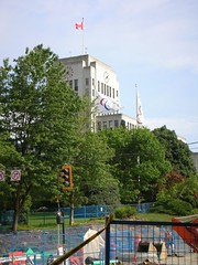
Until 1929, Cambie Street marked the City of Vancouver’s western boundary. Further west lay the municipalities of Point Grey (north of 16th avenue) and South Vancouver (south of 16th avenue). When the current site at 12th avenue and Cambie was chosen in the early 1930’s for Vancouver’s City Hall, protesters opposed its remoteness from the contemporary central city area.
Mayor Gerry McGeer chose the far-flung site for a far-sighted reason - to symbolically and functionally knit the former municipalities of Point Grey and South Vancouver into the central city’s fabric. The municipal boundaries had actually met at 16th avenue, but a mere four blocks does not interfere with good imagery. The city already owned a site at 12th avenue, a nice parcel of land with good views and room to accommodate elegant landscaping. The building of City Hall was completed there in 1936.
In short order, Mayor McGeer’s far-sighted plan for sewing together the urban patchwork that met at 16th and Cambie seems to have been a success. As reported in the “History of Metropolitan Vancouver” website, the building of City Hall “spark[ed] an extension of the Cambie streetcar line and that, in turn, would spur development of the area.”
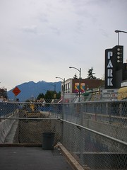
If the extention of a streetcar line down Cambie lead to development of the Cambie Village commercial strip seventy years ago (the landmark Park Theatre dates from around this time), then what might be the effects of the Canada Line on the area once it is completed? History suggests the changes could be dramatic.


No comments:
Post a Comment