For any interested readers, my final paper for the Urban Geography class of which this blog is a part is available here.
This paper mostly explores connections between the Canada Line project as a whole and the 2010 Olympics in the light of this region's courtship of transnational flows of capital and tourists. Some implications for the Cambie Village are also covered, including the "Open for Business" and "I Shop the Line" marketing campaigns that were invented to combat the negative impacts of Canada Line construction.
Happy reading!
Sunday, August 5, 2007
Monday, July 30, 2007
Final Thoughts on Cambie
To follow up on the issues explored in the previous few posts about the Cambie Village area's function within Vancouver in the past and present, I raise a few parting questions about the area's potential function in the city.
As higher-density nodes appear around the Canada Line stations and perhaps along the Cambie Village strip as well, Cambie street could eventually function to as a centre of retail, services and culture. It could connect surrounding areas (rather than act as a border between them), drawing people from other parts of the city with an interesting street life. However, Cambie's uncompromised status as a major traffic artery will pose a challenge towards use as a neighbourhood centre in the way that Commercial Drive now functions.
What do you think will define the Cambie Village area in the near future? That future is almost here, but its features remain shadowy for now.
Sunday, July 29, 2007
Trends for the Future
Do you remember the famous corner of 16th Avenue and Cambie St, where three municipalities once met? Today it showcases trends that are likely to affect the Cambie Village as a whole.
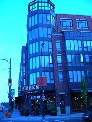
Two years ago, a new multi-story mixed-use retail development went in at the northwest corner of the intersection, featuring a large Capers market on the ground floor, with condos above.
Last month, a swath of single-family homes on the northeast corner (along 16th avenue) were demolished to make room for new condominium construction. This picture, taken on May 30 of this year, shows the corner of the Canada Line Information Centre and the house next door.
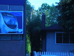
This photo, on July 4 shows that the house is gone (along with many of its neighbours along 16th Avenue).
Yes, that is a realtor's sign along the fence. Unbuilt condos are already for sale!
This kind of large-scale redevelopment is not (yet) widespread within the streets surrounding the Cambie Village strip. However, North of Broadway, mixed-use developments which include condos are growing like mushrooms along Cambie Street towards the future "Olympic Village" along False Creek.
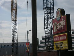
Today, standing at Cambie and Broadway and looking across the bridge towards downtown, you see a skyline bristling with cranes. I wonder how far up Cambie the new condo buildings will stretch within a few years. While new development in the Cambie Village area (particularly near the northern end) is ostensibly independent from Canada Line construction, I do think that the pace of change is related to the coming rapid transit line.
Thursday, July 26, 2007
Will the Canada Line Bring an Economic Boost?
A recent post in the Liveable Region Blog brought to my attention the possibility that the suburban Sheppard Subway line in Toronto faces possible closure closed due to insufficient use. This story ties in rather neatly to the last issue surrounding the Cambie Village and the coming Canada Line that I'd like to explore before wrapping up this blog project: the future of the Cambie Village area.
Do I think the Canada Line will be at risk of closing due to underuse? Not a chance, although I won't be surprised if ridership initially falls below projections, necessitating government support. Rather, the Cambie connection that caught my attention in the blog post about the Sheppard line was this piece of information:
"Although the line was not placed in an ideal location", the new Sheppard line subway "has spurred over $1 billion of construction of new housing, including several high-rise condominium towers along its route."
Politicians such as BC Transportation Minister Kevin Falcon expect that completion of the Canada Line will bring unprecedented prosperity to the Cambie Village area. (This CBC news article explains Mr. Falcon's theory of a coming "economic boost.") Doubtlessly, such a boost would be reflected in rising property values as well as (even more quickly) sprouting condos.
Wouldn't new development be great news for the small businesses along Cambie, as well as for the sense of neighbourhood which is now forming there? Not if change happens too rapidly.
In the long term, changes such as the replacement of many of the old single-story storefronts along Cambie with new multi-level mixed-use developments are bound to occur and would be beneficial in terms of increased density and utility. However, Vancouver's ever-inflating real estate bubble and a municipal policy of densification means that these kinds of changes happen at astonishing speed. Rising costs alienate long-standing local businesses and residents.
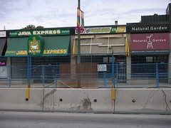
Many business tenants who are now currently surviving Canada Line construction fear that they will ultimately be driven out of the area if rising property values translate into inflated rents that only high-turnover chain stores can pay. Others fear eviction if the aging shop buildings they occupy are torn down and replaced with gleaming new mixed-use developments. (Similar concerns are expressed by the owner of the Vintage Violins music shop in this Vancouver Sun article.) The empty shops now in the area can't be helping the area's stability.
The construction boom surrounding even Toronto's ill-advised, underused suburban Sheppard subway line suggests that rising land values are likely to bring rapid changes to the available types of housing surrounding the Cambie Village area as well. As older single-family homes and duplexes are razed to make way for more condominiums, higher densities will be achieved, but affordability in the area is no more likely to improve for residents than for businesses.
Tuesday, July 24, 2007
The Cambie Village a present-day boundary zone? (Part II: East and West)
 Residents of East Van, or "The Republic of East Vancouver," might argue that their district boasts the most vital and tolerant communities, while many a condo ad emphasizes a "West Side" location, or even "West Side School Catchments area". In either case, local allegiances are defined along an east-west divide. This distinction dates back more than a century to the days when the CPR owned most of the land in western Vancouver. CPR land was subdivided into larger, more neatly organized, was sold to the wealthy.
 Vancouver's avenue names change from "west" to "east" one block west of Main street, or four blocks east of Cambie. Of the four neighbourhoods that connect in the Cambie Village area, two (Mount Pleasant and Riley Park) extend into East Vancouver. Cambie Village businesses serve both the east and west sectors of the city.
Canada Line construction certainly did not cause Vancouver's long-standing east-west rift, but in the opinion of one East Vancouver-based blogger, construction's toll on the area means that, "in becoming a victim street, labouring beneath conditions imposed upon it from wealthier parts of town.... Cambie... may now unofficially be considered part of East Van -- the part of town that has things... dumped on it, not the part that does the dumping".
As construction grinds on, "Cambie Canyon" acts more like a functional border between East and West Vancouver and less like a zone of connection. The invisible boundary dividing East Vancouver from the more politically powerful west side could be drawn along Cambie street.
In a Vancouver Sun article published this May, journalist Frances Bula points out that ongoing construction along Cambie street interrupts the city's daily functioning, tearing the urban fabric into east and west segments. Disruptions to regular intra-urban flows along Cambie's north-south axis bisect the cityscape nearly in two and create a "physical and psychological east-west barrier," for example making it difficult for children who live on one side of Cambie to get to their schools on the other side. She half-seriously compares the rift to the Berlin Wall, likening overburdened single-lane intersections to West-East checkpoints.
An official Canada Line map (above) shows the extent to which the Canada Line geographically bisects the city.
Much has been made in local media of a rapid-rail project in Seattle which is similar in scope to the Canada Line. Unlike the Canada Line, the Seattle project includes dedicated community development funds in its budget (from the federal government) for supporting local business during the difficult construction period. The Executive Director of the [Seattle] Rainier Valley Community Development Fund recently visited the Cambie Village and, like Francis Bula in the Vancouver Sun article noted above, compared Canada Line construction to the Berlin Wall. I suspect this is not the kind of international attention that the Canada Line funders intend to seek!
The Cambie Village a present-day boundary zone? (Part I: Neighbourhoods)
Nestled right in the middle of present-day Vancouver, The Cambie Village area no longer forms any municipal boundary. However, as Canada Line construction continues, the area functions more like a boundary zone than its central location might suggest.
The Cambie Village area has defined the edges of surrounding neighbourhoods since long before Canada Line construction began. When the City of Vancouver moved its planning focus towards neighbourhood planning in the 1970's, planners identified functioning neighbourhoods and defined unique "neighbourhood plans" in cooperation with local residents. CityPlan, a Vancouver-wide planning framework, concludes that Vancouver is made up of diverse neighbourhoods: "villages within a city, each with its own identity". Where three municipalities once met at the intersection of 16th avenue and Cambie, no less than four officially-defined Vancouver neighbourhoods now connect. These are Mount Pleasant, Fairview, South Cambie and Riley Park/Little Mountain, each with its own neighbourhood plan. I wonder why the Cambie Village area seemed to be the best border when these neighbourhood boundaries were set, presumably in the 1970's. As a major six-lane auto route, did Cambie Street lack cohesiveness or vitality? Did it serve more dispersed areas of residences and offices than, say, Main St, or Arbutus St? Perhaps the neighbourhood boundaries were simply chosen for historic reasons.
Awareness of the Cambie Village area as a functioning urban unit may be very recent indeed. Definition of its boundaries is the subject of polite disagreement. The City of Vancouver's "Cambie Street Improvements" plan places the Northern boundary at City Hall, defining the Cambie Village's extent from 12th avenue to 25th Avenue. On the other hand, the Cambie Village Business Improvement Association defines the area as extending another ten blocks north to 2nd Avenue. This latter view includes the Canada Line stations at Olympic Village (2nd Avenue), Broadway (9th Avenue) and King Edward (25th Avenue). The latter definition emphasizes what the area stands to gain from the future Canada Line.
I haven't been able to find any use of the name "Cambie Village" before Canada Line construction began and the Cambie Village Business Improvement Association was created in 2006. Nor, as far as I know, was there a planning effort to develop a cohesive built environment along the strip before the recent Cambie Village Streetscape Plan. A great deal of community consciousness has arisen in the Cambie Village over the last two years, born of hardship related to construction.
Monday, July 16, 2007
Historic City Boundaries along Cambie
Digging into Cambie's history excavates some surprises. Unlike many of the commercial strips that are centres of Vancouver neighbourhoods, Cambie did not grow up around a streetcar line. In fact, while 4th Avenue and Main street were busily developing into commuter suburbs, Cambie Street was still officially the boonies.
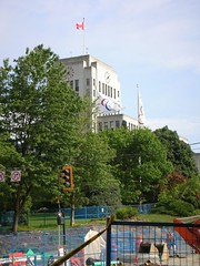
Until 1929, Cambie Street marked the City of Vancouver’s western boundary. Further west lay the municipalities of Point Grey (north of 16th avenue) and South Vancouver (south of 16th avenue). When the current site at 12th avenue and Cambie was chosen in the early 1930’s for Vancouver’s City Hall, protesters opposed its remoteness from the contemporary central city area.
Mayor Gerry McGeer chose the far-flung site for a far-sighted reason - to symbolically and functionally knit the former municipalities of Point Grey and South Vancouver into the central city’s fabric. The municipal boundaries had actually met at 16th avenue, but a mere four blocks does not interfere with good imagery. The city already owned a site at 12th avenue, a nice parcel of land with good views and room to accommodate elegant landscaping. The building of City Hall was completed there in 1936.
In short order, Mayor McGeer’s far-sighted plan for sewing together the urban patchwork that met at 16th and Cambie seems to have been a success. As reported in the “History of Metropolitan Vancouver” website, the building of City Hall “spark[ed] an extension of the Cambie streetcar line and that, in turn, would spur development of the area.”
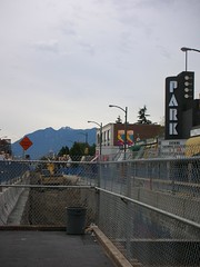
If the extention of a streetcar line down Cambie lead to development of the Cambie Village commercial strip seventy years ago (the landmark Park Theatre dates from around this time), then what might be the effects of the Canada Line on the area once it is completed? History suggests the changes could be dramatic.
Until 1929, Cambie Street marked the City of Vancouver’s western boundary. Further west lay the municipalities of Point Grey (north of 16th avenue) and South Vancouver (south of 16th avenue). When the current site at 12th avenue and Cambie was chosen in the early 1930’s for Vancouver’s City Hall, protesters opposed its remoteness from the contemporary central city area.
Mayor Gerry McGeer chose the far-flung site for a far-sighted reason - to symbolically and functionally knit the former municipalities of Point Grey and South Vancouver into the central city’s fabric. The municipal boundaries had actually met at 16th avenue, but a mere four blocks does not interfere with good imagery. The city already owned a site at 12th avenue, a nice parcel of land with good views and room to accommodate elegant landscaping. The building of City Hall was completed there in 1936.
In short order, Mayor McGeer’s far-sighted plan for sewing together the urban patchwork that met at 16th and Cambie seems to have been a success. As reported in the “History of Metropolitan Vancouver” website, the building of City Hall “spark[ed] an extension of the Cambie streetcar line and that, in turn, would spur development of the area.”
If the extention of a streetcar line down Cambie lead to development of the Cambie Village commercial strip seventy years ago (the landmark Park Theatre dates from around this time), then what might be the effects of the Canada Line on the area once it is completed? History suggests the changes could be dramatic.
Subscribe to:
Posts (Atom)

